![](/images/other/stat-length.png)
![Excursión Senderismo Le Lavandou - Les Balcons de Cavalière - Le Temple d'Hercule - Photo](https://media.geolcdn.com/t/1900/400/ext.pjpeg?maxdim=2&url=https%3A%2F%2Fstatic1.geolcdn.com%2Fsiteimages%2Fupload%2Ffiles%2F1553511878bg_sport_marche.png)
Les Balcons de Cavalière - Le Temple d'Hercule
pourrier
Usuario
![Longitud](/images/other/stat-length.png)
![Altitud máxima](https://static1.geolcdn.com/siteimages/upload/files/1508320355ic_sort_altitude_max_24dp.png)
![Desnivel positivo](https://static1.geolcdn.com/siteimages/upload/files/1508320355ic_sort_den_pos_24dp.png)
![Km-Effort](/images/other/stat-length.png)
![Altitud mínima](https://static1.geolcdn.com/siteimages/upload/files/1508320355ic_sort_altitude_min_24dp.png)
![Desnivel negativo](https://static1.geolcdn.com/siteimages/upload/files/1508320355ic_sort_den_neg_24dp.png)
![Boucle](https://static1.geolcdn.com/siteimages/upload/files/16400158638029165_repeat_loop_refresh_sync_direction_icon.png)
![Senderismo](https://static1.geolcdn.com/sitytour/trail-icons/101.png)
4h28
Dificultad : Medio
![Escanee este código QR para abrir la excursión en la aplicación SityTrail](https://capi.geolives.com/qq0zvz2zws4bq2lad0pu/sitytour/trails/3086429/qr.png?size=200)
Aplicación GPS de excursión GRATIS
A propósito
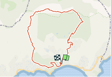
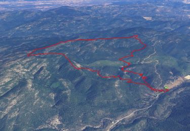
Ruta Senderismo de 10,8 km a descubrir en Provenza-Alpes-Costa Azul, Var, Le Lavandou. Esta ruta ha sido propuesta por pourrier.
Descripción
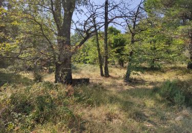
Départ depuis le parking et monter depuis la station de pompage vers le Rossignol à travers les mimosas. Belle vue sur Cavalière.
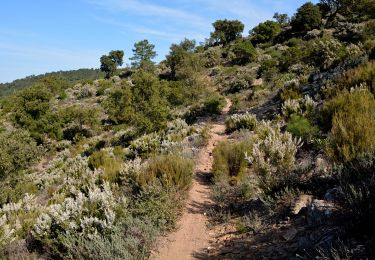
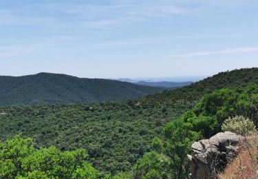
Continuer vers le Col de Barral par le chemin DFCI très large et la route goudronnée. Le chemin n'est pas très plaisant mais la vue est belle.
Poursuivre la montée jusqu'à Sauvaire, poursuivre jusqu'à la citerne et bifurquer à droite par un petit sentier qui descend raide vers le temple d'Hercule via l'ubac du Bleu. Le temple d'Hercule n'est plus accessible pour cause d'éboulis.
Regagner Cavalière par la route qui serpente entre les lotissements.
Promenade à faire en février pour profiter des mimosas.
Localización
Comentarios
Excursiones cerca
![Excursión Senderismo Bormes-les-Mimosas - SityTrail - 3043274 - bargeanxchartreuse-verne - Photo](https://media.geolcdn.com/t/375/260/3db88ff5-5d2e-4949-8a29-14c430fd8c8f.jpg&format=jpg&maxdim=2)
![Senderismo Senderismo](https://static1.geolcdn.com/sitytour/trail-icons/101.png)
Senderismo
![](/images/other/stat-length.png)
![](https://static1.geolcdn.com/siteimages/upload/files/16400158638029165_repeat_loop_refresh_sync_direction_icon.png)
![Excursión Senderismo Bormes-les-Mimosas - Chartreuse de la Verne - Photo](https://media.geolcdn.com/t/375/260/ext.jpg?maxdim=2&url=https%3A%2F%2Fservices.sitytrail.com%2FGeolivesWS%2FDownloadMedia.ashx%3FTrailID%3D898630%26Media%3Dfix__20170215102107.jpg)
![Senderismo Senderismo](https://static1.geolcdn.com/sitytour/trail-icons/101.png)
Senderismo
![](/images/other/stat-length.png)
![](https://static1.geolcdn.com/siteimages/upload/files/16400158638029165_repeat_loop_refresh_sync_direction_icon.png)
![Excursión Senderismo Le Lavandou - Du Lavandou à la Pointe de l'Esquillette - Photo](https://media.geolcdn.com/t/375/260/ext.jpg?maxdim=2&url=https%3A%2F%2Fservices.sitytrail.com%2FGeolivesWS%2FDownloadMedia.ashx%3FTrailID%3D105657%26Media%3D9466_6.jpg)
![Senderismo Senderismo](https://static1.geolcdn.com/sitytour/trail-icons/101.png)
Senderismo
![](/images/other/stat-length.png)
![](https://static1.geolcdn.com/siteimages/upload/files/16400158638029165_repeat_loop_refresh_sync_direction_icon.png)
![Excursión Senderismo Le Lavandou - Balcons de Pramousquier 22.1.23 - Photo](https://media.geolcdn.com/t/375/260/b49f05a7-2e02-450b-a614-7cc169048d9c.jpg&format=jpg&maxdim=2)
![Senderismo Senderismo](https://static1.geolcdn.com/sitytour/trail-icons/101.png)
Senderismo
![](/images/other/stat-length.png)
![](https://static1.geolcdn.com/siteimages/upload/files/16400158638029165_repeat_loop_refresh_sync_direction_icon.png)
![Excursión Senderismo Bormes-les-Mimosas - Boucle : Pont des Caunes - Piste de l'Amandier - Piste de la Gourre - Piste Lambert - Col de la Citadelle - Pont des Caunes. - Photo](https://media.geolcdn.com/t/375/260/93e7f835-4806-4284-8793-c12d2410b0fc.jpg&format=jpg&maxdim=2)
![Senderismo Senderismo](https://static1.geolcdn.com/sitytour/trail-icons/101.png)
Senderismo
![](/images/other/stat-length.png)
![](https://static1.geolcdn.com/siteimages/upload/files/16400158638029165_repeat_loop_refresh_sync_direction_icon.png)
![Excursión Senderismo Rayol-Canadel-sur-Mer - Wikiloc - Le rayon canadel - Opidum de monjean - Photo](https://media.geolcdn.com/t/375/260/4e43ac4c-7667-474b-8d0a-9263d51cfdde.jpg&format=jpg&maxdim=2)
![Senderismo Senderismo](https://static1.geolcdn.com/sitytour/trail-icons/101.png)
Senderismo
![](/images/other/stat-length.png)
![](https://static1.geolcdn.com/siteimages/upload/files/16400158638029165_repeat_loop_refresh_sync_direction_icon.png)
![Excursión Senderismo Le Lavandou - cavaliere - Photo](https://media.geolcdn.com/t/375/260/ext.jpg?maxdim=2&url=https%3A%2F%2Fstatic1.geolcdn.com%2Fsiteimages%2Fupload%2Ffiles%2F1553511878bg_sport_marche.png)
![Senderismo Senderismo](https://static1.geolcdn.com/sitytour/trail-icons/101.png)
Senderismo
![](/images/other/stat-length.png)
![](https://static1.geolcdn.com/siteimages/upload/files/16400158638029165_repeat_loop_refresh_sync_direction_icon.png)
![Excursión Senderismo Rayol-Canadel-sur-Mer - 20190222 rayol canadel - Photo](https://media.geolcdn.com/t/375/260/ext.jpg?maxdim=2&url=https%3A%2F%2Fstatic1.geolcdn.com%2Fsiteimages%2Fupload%2Ffiles%2F1553511878bg_sport_marche.png)
![Senderismo Senderismo](https://static1.geolcdn.com/sitytour/trail-icons/101.png)
Senderismo
![](/images/other/stat-length.png)
![](https://static1.geolcdn.com/siteimages/upload/files/16400158638029165_repeat_loop_refresh_sync_direction_icon.png)
![Excursión Senderismo Bormes-les-Mimosas - Vallons de la Gourre et des Caunes - Photo](https://media.geolcdn.com/t/375/260/1e74f8dd-3531-46df-bd25-c87eb6eff58d.jpg&format=jpg&maxdim=2)
![Senderismo Senderismo](https://static1.geolcdn.com/sitytour/trail-icons/101.png)
Senderismo
![](/images/other/stat-length.png)
![](https://static1.geolcdn.com/siteimages/upload/files/16400158638029165_repeat_loop_refresh_sync_direction_icon.png)